Revamped Downtown Isolated City’s West Side
History shows Providence’s renaissance was selective and ignored minority neighborhoods
October 6, 2016
Share
PROVIDENCE — When the city embarked on its massive Capital Center redevelopment project in the early 1980s, then-mayor Buddy Cianci said: “Times have changed, but there is no reason why we should have to give up our birthright, which is access to the water.”
Beginning in the 1930s, the downtown section of the Providence River — formed by the confluence of the Woonasquatucket and Moshassuck rivers — was filled, paved and covered by railways. By the 1960s, the construction of a hurricane barrier, a highway and its ramps completed a century-long process of making the rivers, the very reason for Providence’s location, invisible and inaccessible.
Downtown was a dead zone. Its economy deteriorated as the textile industry declined, and restaurants and shops closed. Rhode Islanders, never mind tourists, had little reason to visit other than to conduct business or go to a government office.
In an effort to eradicate traffic congestion and draw people downtown, Providence launched its Providence River Relocation project in 1985, uncovering large swaths of the river, creating Waterplace Park, and establishing connecting riverwalks along the downtown banks of the Woonasquatucket and Moshassuck rivers. The entire project, which was completed in 2003, cost $169 million, including rail relocation and the development of highway interchanges.
Throughout the various stages of planning and execution, the project was promoted as part of a Providence “renaissance” — a restoration of downtown to its former industrial glory.
But the city’s renaissance was selective. As the first WaterFire lit up the Providence River in 1994, the Woonasquatucket River, on the other side of Interstate 95 in Olneyville, remained hidden amidst bramble and concrete. The diminishing significance of the Woonasquatucket River’s functional importance as a power source for the city’s once-thriving mill industry left the river underutilized and polluted by toxins and sewage.
This post-industrial river space became a center for criminal activity. Merino Park, along the river in Olneyville, was commonly referred to by residents in the 1990s as “needle park.”
As planners and city officials turned the Providence River into a symbol of the city’‘s rebirth, and, according to the Providence Preservation Society, using it to “glue the city back together.” The section of the river west of downtown, as well as the history embedded in its banks, was entirely neglected. The “birthright” to the water that drove Cianci to support the downtown river redevelopment plan was, seemingly, not a right shared by all.
The Woonasquatucket River, which extends 15.8 miles from North Smithfield in the west to downtown Providence in the east, was given its name — Algonquian for “As Far as the Salt Water Flows” — by the Narraganset tribe, who built a trade center along the river. Colonial settlers, interested in developing trade relationships with the Narragansett, began settling along the river in the Olneyville neighborhood of Providence in the early 18th century.
Significant British colonial settlement began in 1785, after Christopher Olney, for whom Olneyville is named, founded a grist mill and a paper mill along the Woonasquatucket River. From the 19th to early 20th century, the river was the lifeline of the Olneyville neighborhood; the mills that once thrived in the area were powered by the river, and both the New Haven railroad and the Providence streetcar ran along its shores.
Company-owned factory villages sprung up across the watershed, with the river at its center. Providence’s many waterways were a perfect hub for the new industrial economy — ideal for building dams and water wheels. Between 1790 and 1860, nearly 300 textile mills along the river opened.
During the early 19th century, the water was the center not only of the Industrial Revolution but of a transportation revolution. Regular steamship service had been established to Newport in 1817 and to New York by 1819, with rivers such as the Woonasquatucket used to facilitate inland water traffic and to link smaller towns with major ports. The first steam locomotive in New England arrived in Providence in 1831, and railroad tracks were built to follow the path of the Woonasquatucket River, connecting Olneyville to Pascoag.
The Woonasquatucket Railroad was incorporated into the New Haven and Hartford Railroad in the 1850s, which would operate until the 1960s. A few years later, the first gas-powered streetcar ran through Olneyville, with Olneyville Square functioning as one of Providence’s streetcar hubs.
However, the deterioration of the mill industry in Providence eventually rendered the Woonasquatucket River inessential. Beginning in the 1920s, employers began leaving the state for the South, where manufacturing was cheaper. Between 1929 and 1931, employment in Providence declined by 40 percent in the textile industry, 47 percent in the jewelry industry and 38 percent in the base-metal industry.
By the 1950s, the decline of the textile mill rendered the Woonasquatucket River obsolete as a power source. Many of the European immigrants who had lived in the mill towns left for the expanding suburbs. Thousands of jobs were lost and never replaced. Those changes coincided with the arrival of the automobile and the demolition of both the railway and the streetcar. The construction of Route 6 and I-95 contributed to fragmentation of Olneyville, destroying the neighborhood’s traditional ties with the downtown and cutting the neighborhood off from the Woonasquatucket River in several spots.
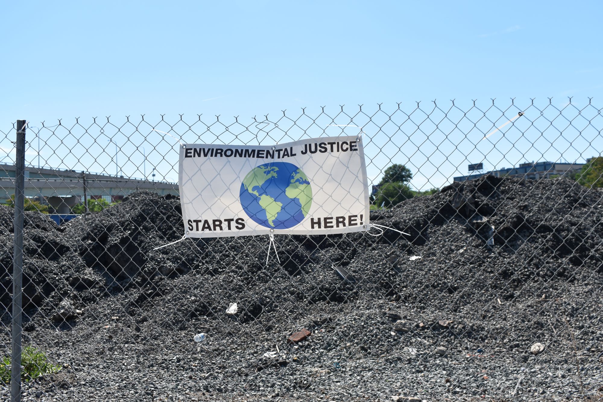
Over the decades of downtown river redevelopment projects and city-sponsored reclamations of Providence’s river history, the history and revitalization of the Woonasquatucket in Olneyville was consistently ignored. Paved in on either bank with asphalt, the river is, in many places, invisible. The Woonasquatucket’s banks are today lined with vacant homes — the vacancy rate in Olneyville is 21.2 percent — higher than the rate of vacancies in 86.8 percent of all U.S. neighborhoods, and crime — in 2002, Olneyville had the third-highest rate of violent crime among Providence’s 25 neighborhoods. The river and its sediment is filled with harmful chemicals and pollutants, and trash.
Like in many cities across the country, neglect of natural resources in Providence almost always occurs in neighborhoods inhabited predominately by people of color. In Olneyville, rapid population decline throughout the 1950s and ’60s drew poorer, immigrant groups to the neighborhood, primarily Hispanic.
Post 1950, southern blacks who had migrated to the North seeking better employment opportunities settled in the neighborhood. The neighborhood’s population shift continued from 1990 to 2000, with the white population dropping by half and the non-white population growing by nearly 75 percent; the Hispanic population alone almost doubled.
The neglect of the Woonasquatucket River hasn’t only robbed residents of their right to the waterfront, but has had dangerous consequences. While flood protections and hurricane barriers have been put in place to safeguard downtown, few such measures have been taken in Olneyville. Nearly half of Olneyville is in a floodplain. In the historic flood of March 2010, Olneyville was the hardest hit among the city’s neighborhoods.
During the flood, the bridge connecting the neighborhood to Eagle Square Marketplace was heavily damaged. Since many residents are renters, most don’t have insurance coverage for their belongings, and many landlords don’t have flood insurance coverage.
Organizations such as the Woonasquatucket River Watershed Council (WRWC) have stepped in to fill the void left by government neglect. Since its formation in 1993, WRWC has worked to clean up the river and make it accessible to locla residents, primarily through the creation of some 60 miles of bike paths and green space along the river.
The installation of fish ladders has helped mitigate the damage dams have done to the Woonasquatucket River’s fish populations. WRWC educational programs in Olneyville schools have brought students to the river and taught them about the watershed’s ecosystem. These efforts have been successful in reintroducing the river into the fabric of the neighborhood, but the impact of decades of neglect aren’t easily erased.


I think this seriously underestimates the effort including a lot of public money to develop the parks and bikeways along the Woonasquatucket and the success it has had. There is also the effort to build the Providence Community library including its branch in Olneyville which the Providence PUBLIC Library had once threatened to close.
The downtown "renaissance" got a lot of money but its hard for me to see that Olneyville and the west had any less attention than any other Providence neighborhoods. What did the North End, South Side, Mt Pleasant etc get that the west did not?
The alleged "community of color" aspect to this seems unconvincing and inappropriate.
Great article. I am sure I have a few quibbles, but the one to point out is that by the early 18th Century there was not a lot of trade going on with the Narragansett Nation which had endured hard times after the Great Swamp massacre of 1675. I am guessing trading posts in Olneyville would have dated to the 1650’s.