From the Great Salt Cove to Waterplace Park: How Hardening Downtown Providence’s Waterways Affects Flooding Today
March 18, 2026
Share
PROVIDENCE — When Giovanni da Verrenzado — the first European to explore New England’s Atlantic coast — first sailed into the Narragansett Bay in 1524, he was greeted by a very different Providence than today. A jagged coastline of rocks and flowing estuaries lay before him. No hurricane barrier, no windmills.
Development of rivers has drastically changed Rhode Island’s landscape. This large-scale human interference now contributes to the increased rates of flooding plaguing the city.
Courtney Schmidt, a staff scientist at the Narragansett Bay Estuary Program, is particularly fascinated by the intersection between human history and ecology in urban areas. She used to wonder why humans make the same mistakes repeatedly when building in flood zones, until the answer dawned on her.
“A human life is about 100 years, and we don’t learn,” Schmidt said. Even though humans have had the technology to prevent catastrophic flooding for years, “we don’t because we don’t like to think about it. We have all these other draws on our time and thoughts.”
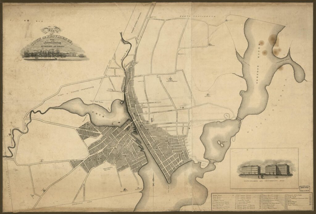
Before Europeans settled Rhode Island’s capital, the Providence River — which flows from the confluence of the Woonasquatucket and Moshassuck rivers down past the Fox Point Hurricane Barrier — was a passageway between the Narragansett Bay and a large saltwater marsh known as the Great Salt Cove.
The Great Salt Cove was the “head of where the Woonasquatucket, Moshassuck and now Providence rivers all met,” said Schmidt.
The cove, which existed where downtown Providence now stands, was a vastly different landscape. Schmidt says it was a shallow river with a very different flow.
“We have maps up until the 1800s that say that seagrasses were in the Providence River, which is something that you don’t see up here now,” Schmidt said.
But that landscape has since changed due to rampant river hardening — the use of hard materials, like concrete or rocks, to line the shore of a river to prevent overflow from tides or to redirect the river entirely.
According to a 1990 article by Michael Holleran, an associate professor of architecture at the University of Texas at Austin, land where the Providence Cove once lay “is doubtlessly the most reworked piece of land in Rhode Island and among the most reworked in North America.”
Urban development near the salt marsh first began because the grasses were the best hay for livestock, Holleran said. But after the introduction of industry to the area — starting with Samuel Slater’s mill on the Blackstone River — Providence saw rapid growth, and with it, the hardening of its river.
Holleran said there were many reasons for hardening of the river, including the need for a “navigable and harborlike” body of water near the city, a desire to define the riverbanks and, later, the need to contain waste.
But “development never really does anything good for flooding,” Schmidt said.
As downtown Providence continued to grow, the banks of its river began to shrink. The first spell of disaster hit in 1815 with a storm known as “The Great Gale.” Now understood to be a hurricane, the gale brought an eight-foot storm surge.
Despite the storm’s large toll on Providence, residents and developers continued to build and further channelized the estuary. But another key issue confronted residents — the need for a sewage system.
The cove and other parts of the rivers were filthy with excrement, animal carcasses and other human-caused waste, Holleran said.
“When you talk about industrialization and this urbanization as we did in the 1700s, 1800s, you also start talking about cholera outbreaks,” Schmidt said. Since people at the time would dump waste either in the streets or use latrines, flooding from the river would bring it into the water.
Further paving over the cove lessened the likelihood that human waste would get into the water, which residents used as a “sink” for drinking, bathing and other activities, Holleran said. But though this hardening helped at the time, it did not account for sea level rise or stronger storms in the future.
The final blow to the cove’s existence came later, with the development of the railroad, Schmidt said. When building the new tracks, city plans placed the new Union Station directly on top of the greatly shrunken cove. After the rail line was built, the cove and most of the city’s downtown waterways vanished underground.
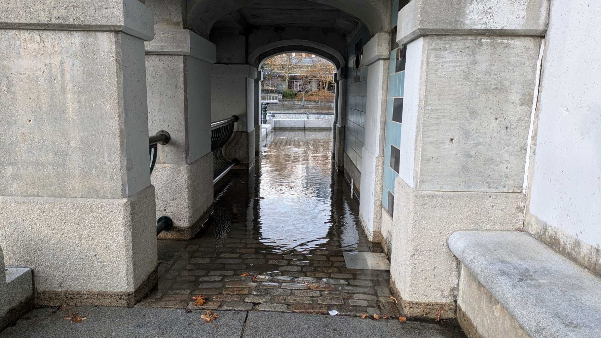
More recently, much of Providence’s waterways have been uncovered as part of an effort to restore the downtown area. As a component of this plan, the city built Waterplace Park in the 1990s in the Woonasquatucket River, just upstream from where it merges with the Moshassuck. The park’s circular-like shape pays homage to the cove.
But now, due to extreme alterations in the river from hardening and rising tides due to climate change, the city sees increased flooding.
In emergency management, flooding is divided into three categories: riverine flooding, which concerns the volume of water flowing downstream; storm surge flooding, or tidal flooding, which comes upstream; and flash flooding, which is caused by heavy rainfall on impervious surfaces, according to Clara Decerbo, director of the Providence Emergency Management Agency.
During large storms, these types of flooding converge to raise river levels. But fighting water is not easy.
Water flows extremely well over impervious surfaces since it takes the path of least resistance, Schmidt said. With so much development and so many buildings along the river that replaced the salt marsh, water easily creeps up onto walkways.
“One of the pieces that is commonly misunderstood and also misconstrued in discussions about flooding in downtown Providence is what role the hurricane plays,” Decerbo said.
With large storms like hurricanes, the barrier can be closed to prevent high tidal flooding of the rivers, but it would not help fight flash or riverine flooding, which are caused by heavy rainfall inland and worsened by developed impervious surfaces.
During king tide events — when high tides reach their highest levels — parts of downtown Providence, like Waterplace Park, often flood due to higher river levels. But these flooding events are not currently of major concern to the city or the Army Corps of Engineers, who manage the Fox Point Hurricane Barrier.
“The City of Providence and the Army Corps of Engineers allow some level of the pavement getting wet … in Waterplace Park because, for a high tide event, it’s not damaging anything,” Decerbo said.
Each time the Army Corps closes the barrier, it costs the federal government “tens of thousands of dollars,” she added. “To keep a sidewalk dry for a couple of hours is not an effective use of resources.”
Riverine flooding is increasingly dangerous for Providence because there has not been a major instance since March 2010, when a mix of snow melt, rain and lack of vegetation contributed to high river levels across the state, Decerbo said. Lack of knowledge about potential events puts residents at risk.
Casey Tremper, a coastal resilience specialist with Rhode Island Sea Grant, works on Rhode Island’s MyCoast, an application where the public can submit flooding photos. Tremper has been working to expand the reach of MyCoast to include tidal flooding throughout Rhode Island.
Every photo uploaded to MyCoast is geotagged and includes information on tides, storms and other pertinent information to the image, Tremper said. With these photos, Tremper and MyCoast seek to communicate with the public, municipalities and the scientific community about rising water levels across the state.
According to Eliza Berry, another coastal resilience specialist with Rhode Island Sea Grant, most cities and municipalities do not have advanced systems to track flooding.
“They only know that a specific intersection is flooding all the time because they are getting calls from residents or because there’s some guy in public works (who) knows he’s always getting called out to clear the storm drain in that spot,” she said.
“A picture is worth a thousand words in communicating,” Tremper added. “I know that municipalities have used these pictures in grant applications to show ‘This is the problem. We know what’s causing it. We would like to propose this grant for this solution.’”
Through the Providence Riverwalk Resilience Project, the city is currently working to redesign Waterplace Park and parts of the Providence River’s banks to be more resilient towards sea level rise, Decerbo said.
But no work can start until after engineering and permitting is done, which is slated for completion in early 2027. The project is also contingent on federal funds, which could be uncertain with the Trump administration slashing spending on sea level rise protection projects.
So, for now, Waterplace Park may be a bit wet when high tides hit.
“Water will move itself where it wants to go,” Schmidt said. “It’s only when we have … hardened everything and changed the ecosystem that we now have to contend with all the things that Mother Nature… has contended with long before we were here and will contend with long after we’re gone.”
This story was published as part of a collaboration between ecoRI News and students in Brown University’s Science Journalism class. The stories examine the science, history, and human experiences connected to the Ocean State’s rivers — from water quality and wildlife restoration to flooding, pollution, social justice, and the communities working to protect them. To read more of these stories, click here.