Charlestown Breachway, Vital to the Health of Ninigret Pond, to be Rebuilt
October 13, 2025
Share
CHARLESTOWN, R.I. — When the Charlestown Breachway’s western wall ruptured two winters ago, thanks to a series of strong storms, town officials caught an unusual lucky break.
While sand and sediment flowed directly into the channel, town officials were already planning to replace the breachway, as its current iteration entered its seventh decade of use and its design approached the end of its life.
Having a plan already in place allowed the town to work together with the Rhode Island Department of Environmental Management, the entity that actually owns the breachway, the Coastal Resources Management Council, and others to rebuild the damaged portion of the 200-foot-long breachway that has cut a permanent channel into Ninigret Pond since 1952.
“The town really deserves big kudos for the planning they did ahead of time,” said Emily Hall, a coastal geologist for CRMC. “The fact they were doing that MRP process before it was an actual emergency, it’s a perfect example of how cities and towns can be proactive and not just react to emergencies.”
Now state and town officials are preparing to kick off the final permanent rebuild of the breachway later this month. On Sept. 22, the Town Council approved contracts for three contractors: RMA Environmental LLC, the designated engineering firm of record; CAB Construction, the company that will repair and construct the wall and associated dune restoration; and J.F. Brennan Company Inc., to dredge the channel starting in January.
The final price tag on the project is $8.4 million, sourced from a combination of state and local money. Earlier this year the General Assembly approved a $5 million allocation from Gov. Dan McKee to help pay for the project, $2 million is being paid by CRMC as part of being the state sponsor of the dredging, and the town is kicking in another $1.4 million to pay for its portion of the project.
“It’s more than just a structure,” town administrator Jeffrey Allen said in a statement. “It provides connectivity to our coastal environments, supports our economy and functions to foster our community.”
The contractors are scheduled to start mobilizing equipment and materials, using Blue Shutters Beach town parking lot as a pre-staging area. Boulders to be used in construction of the new breachway walls will be delivered and stored on the lot until November. Once construction begins, the materials will be transported along East Beach to the breachway’s construction site.
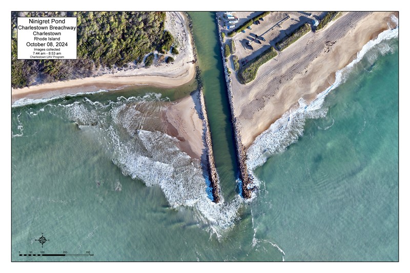
The new Charlestown Breachway will be taller, enough to accommodate the projected sea level rise facing Rhode Island by the end of this century. The walls of the new breachway will be between 8 and 9 feet tall, over twice as tall as they are now.
Hall said the new design involves multiple layers of large, interlocking stones. The new breachway will consist of massive angular boulders, weighing up to 3 tons each, that will act as core stones in the center of the construction. On top of those core boulders will be armor stones which will be much smoother and absorb most of the wave action.
“It’s going to be structurally sound by the design standards of 2025 rather than the design standards of the 1950s,” Hall said.
The current iteration of the Charlestown Breachway dates back to 1952, when the Rhode Island Harbor and Rivers Commission built its walls in a handful of days. But Rhode Islanders had been digging and constructing human-made channels between Ninigret Pond and Block Island Sound since at least the late 19th century.
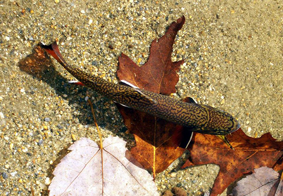
At 1,500 acres, Ninigret Pond is the largest of South County’s saltwater coastal lagoons that run parallel to the Atlantic Ocean. While the breachway channel is human-made, it provides benefits for both residents that live along the pond and the aquatic wildlife and plant life living in the water.
The breachway’s key benefit is flushing out Ninigret Pond and providing a continuous source of new salt water. Without the breachway, over time the salinity of Ninigret Pond would decrease and it would became a waterbody much closer to fresh water than salt. But salt water is necessary for eelgrass species to thrive, and for the pond’s aquaculturists to be able to grow their oysters.
But probably the most important result of the breachway is that it cuts down on flooding, and Hall said Rhode Islanders don’t have to look too far to find out what life without the Charlestown Breachway would look like.
Take South Kingstown’s Cards Pond, or Westerly’s Maschaug Pond. Both are coastal lagoons near the ocean, with plenty of private residences around and no breachway in sight. When the ponds are hit with rain their banks swell, and the floodwater has to go somewhere, and that somewhere is someone’s backyard.
“It comes down to, this is the habitat we prioritized,” Hall said. “We want [the pond] to be a well-draining, salty brackish habitat that’s going to support aquaculture and eelgrass. It would be fine, environmentally wise, if we closed the breachway, but it’d be a very different habitat at that point. It wouldn’t be as brackish, and it wouldn’t be as much of a fish nursery as we have right now.”