East Providence Erosion Project Brings Shoreline to Life
Longtime ocean advocate hails comeback of overlooked stretch of Rhode Island coast
July 5, 2021
Share
EAST PROVIDENCE, R.I. — Growing up in the 1970s and ’80s across the Seekonk and Providence rivers in Rhode Island’s capital, John Torgan spent plenty of time exploring the state’s urban shoreline.
He remembers them as dumps filled with sewage and littered with decaying oil tanks.
“They were horribly polluted,” said Torgan, who still lives in Providence. “No one was fishing or sailing.”
His childhood memories, however, also include the beauty of a peaceful island in the middle of a shallow 4-mile-long salt pond.
The fortunes of these waters and their surroundings have changed since an adolescent Torgan, now 51, was skipping rocks, collecting shells and investigating the coastline for marine life. The Providence and Seekonk rivers are still impaired waters, but, like the chain-link fence topped with barbed wire that once separated much of these waterways from the public, the derelict oil tanks have been removed. The rivers’ health has improved.
The two rivers, both of which share a legacy of industrial contamination and suffer from stormwater runoff pollution, aren’t recommended for swimming, but life on, under and around them has returned. Menhaden, bluefish, river herring, eels, osprey and cormorants are now routinely spotted. The occasional seal, dolphin, bald eagle and trophy-sized striped bass visit. Kayakers, fishermen, scullers and birdwatchers are easy to find.
Torgan, who spent 18 years as Save The Bay’s baykeeper, called the comeback of upper Narragansett Bay “extraordinary” and “dramatic.” He credited the Narragansett Bay Commission’s ongoing combined sewer overflow project with making the recovery possible.
As for that summer cottage on Great Island in Point Judith Pond, he said “tremendous development” has changed the neighborhood. Bigger houses now surround the Torgan family’s saltbox cottage, adding stress to one of Rhode Island’s largest and most heavily used salt ponds.
There is a diverse mixture of development around the shores of the pond that straddles South Kingstown and Narragansett. In the urban center of Wakefield at the head of the pond and at the port of Galilee at its mouth, there is an abundance of commercial development and a corresponding amount of pavement. The impacts are beginning to show.
Early last year the Rhode Island Department of Environmental Management decided, based on ongoing water quality monitoring results, to reclassify two areas of Point Judith Pond from approved to conditionally approved for shellfish harvesting. Water samples collected in the pond after certain rain events showed elevated bacteria levels and resulted in several emergency and precautionary shellfishing closures.

As an adult, Torgan’s interest in and passion about the marine environment hasn’t waned. The avid boater and angler has spent much of his working life protecting the Ocean State’s namesake, especially the waters not typically associated with its catchy moniker.
“This is the coast,” Torgan said while standing at the water’s edge at Rose Larisa Memorial Park. “The coast of Rhode Island doesn’t start at Rocky Point. It’s not just the beaches of South County.”
But, like most of the state’s coastline, the East Providence shoreline is vulnerable to accelerated erosion driven by the climate crisis and growing development pressures. Like much of the state’s urban shoreline, the health of this stretch of beach is better but hardly pristine. It is littered with chunks of asphalt and broken glass, most of its sharp edges dulled by tumbling in the sea. Swimming isn’t advised.
The climate challenges and improved health are why the organization Torgan currently heads, the Rhode Island chapter of The Nature Conservancy, took an interest in protecting this underappreciated stretch of beach.
More frequent and intense storms, combined with increasing sea-level rise, are eroding beaches and bluffs and damaging the state’s diminishing collection of coastal wetlands. Torgan said dealing with the negative impacts of this reality, plus increased flooding, is a huge challenge for Rhode Island’s 21 coastal communities. He noted adequately supported coastal resiliency projects that use nature are needed to inoculate the state against the changes that are coming.
To that end, The Nature Conservancy partnered with the Coastal Resources Management Council (CRMC) and the city of East Providence last year to test the effectiveness of “living shoreline” erosion controls at the popular Bullocks Point Avenue park.
The park’s steep coastal bluff rises 20-30 feet above a narrow beach. In several areas, however, erosion has crumbled sections of the bluff, exposed root balls and felled trees. Previous efforts to reduce erosion through human-made practices, such as the installation of riprap and seawalls, failed.
As its name suggests, the living shoreline model incorporated more natural infrastructure. Unlike concrete or stone seawalls, living shorelines are designed to prevent erosion while also providing wildlife habitat. Hardened shorelines, compared to living ones, also diminish public access.
The first step in returning nature to a prominent role at this coastal park, at the head of Narragansett Bay’s tidal waters, was removing debris, such as large concrete slabs more than 20 feet long that were sitting at the bottom of the bluff, left behind by those failed human attempts to keep Mother Nature at bay.
Then, at the northern end of the park, the bank was cut away to reduce the slope. Stone was placed at the base of the bluff and logs made of coconut fiber were installed farther up the slope. The bluff was planted with native coastal vegetation. Near the southern boundary, low piles of purposely placed rocks and rows of beachgrass and native plants were added.
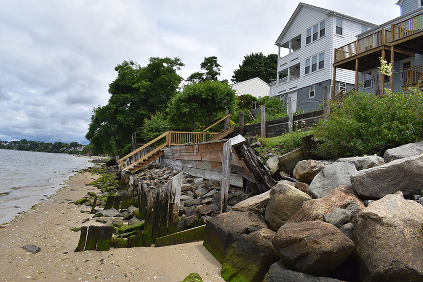
In other areas along this stretch of upper Narragansett Bay beach, boulders, cement walls and wooden structures, to varying degrees of success, strain to keep East Providence backyards from eroding and the bay from encroaching.
“As a matter of policy, we need to change our relationship with water where we’re not trying to hold it back and keep it out,” Torgan said. “In a more comprehensive way, think about how can we manage it and create basins where we are welcoming the water. That will help with flooding. It will help with sea-level rise and storm damage. It will improve water quality. The long view is changing the mindset that says we need to wall off the rising water and instead think about natural approaches and strategies that allows us to move with it.”
He noted that while living shoreline techniques have been implemented elsewhere in the United States, few have been permitted, built and evaluated in New England. He said small-scale projects like this one give coastal engineers and coastal permitting agencies a better sense of their cost and effectiveness, most notably in areas that aren’t exposed to open-ocean shoreline, like along much of the South Coast, where these artificial marshes would likely be unable to blunt stronger wave action.
When the 2020 project was announced, CRMC board chair Jennifer Cervenka said, “Much of Rhode Island’s coastline is eroding, and it’s a problem with no easy fix. This nature-based erosion control is one of the first of its kind in Rhode Island, and New England. We can’t stop erosion completely, but living shoreline infrastructure like this might buy our shores some valuable time.”
The project, which cost about $230,000, was funded by a Coastal Resilience Fund grant from the National Oceanic and Atmospheric Administration, The Nature Conservancy, the Newport-based foundation 11th Hour Racing and the Rhode Island Coastal and Estuarine Habitat Restoration Trust Fund.
Love this project and Rose Larissa Park and would love to see even more removal of human-made materials and use of purposefully-engineered living erosion control. These Bay access points are huge!
Great use of money. Urban shoreline should be given it’s due after years of neglect. Great job. Hope your efforts are a model for improvements in other parts of the upper Bay.
I used to drive out from the city and park at an abandoned house on a high bluff at Bullock’s Point. The house next door was a farmhouse. The spot was beautiful. I’m so glad that it’s being dynamically managed and appreciated. I wish I’d asked questions in the 80’s, when I was there. Thank you for this.
I LOVE the project at the park! I walk and run the beach; I have for years. My heart hurts though as I watch erosion consume the sections north of the project. I’m looking forward to a more natural approach to remediate those areas.
This park has come such a long way ❤️It’s beautiful and I’m so glad this project is happening, it was sad to walk along the beach before and see the trees and hillside collapsing . Hoping it can be used in other places there are spots along the beach in Goddard park that look the way Rose Larisa park used too . If there were any. Way to do something like this in South Kingstown it would be amazing.