Removal of Potter Hill Dam Would Improve Pawcatuck River Fish Passage, Reduce Flooding Risks
March 20, 2021
Share
Rhode Island residents, state legislators, and municipal officials were recently presented with several options regarding the future of the deteriorating Potter Hill Dam, which once powered Westerly’s Potter Hill Mill.
During a March 18 online public information meeting, participants applauded the proposal to remove the only remaining dam on the Pawcatuck River, but some residents worried that removing the dam would significantly lower the water level of the river, draining wetlands and impacting wells and property values.
Funded by a $100,000 grant, the first funding of a multiyear award from the National Oceanic and Atmospheric Administration (NOAA), the project has received additional monetary and in-kind donations totaling $112,500.
Participating groups, in addition to NOAA, are The Nature Conservancy, the Westerly Town Council, the Westerly Conservation Commission, the U.S. Fish & Wildlife Service (USFWS), the U.S. Geological Survey, the Rhode Island Department of Environmental Management, the Southern Rhode Island Conservation District, and the Wood-Pawcatuck Watershed Association (WPWA). (The town of Hopkinton borders the river on the other side, however, the study doesn’t have a Hopkinton representative.)
The derelict Potter Hill Mill, recently the focus of a failed private redevelopment plan, continues to crumble into the river. The Potter Hill Dam, first built in the 1780s and rebuilt in the early 1900s, is also failing. Both the dam and the mill are currently in receivership.
Westerly director of development services Lisa Pellegrini described the site as “a big, expensive problem,” which, in addition to posing a public safety hazard, puts the town at an increased risk for flooding.
“If the dam fails, there will be a devastating flood that will greatly affect Westerly,” she said.
Water resources engineer Nils Wiberg, of the Providence-based environmental engineering firm Fuss & O’Neill, presented a technical overview of the study, which evaluated several options for removing part or all of the dam.
The project will be the final step in an initiative that began a decade ago with fish passage enhancements at the Lower Shannock, Horseshoe Falls and Kenyon Mill dams, followed by the removals of the White Rock and Bradford dams.
“So here we are at Potter Hill dam, which is, I’ll say, the last significant barrier to upstream migration,” Wiberg said. “There is a fish ladder there. That fish ladder is probably on the order of 30 or 40 years old.”
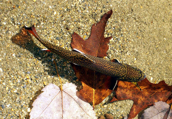
The existing fish ladder is outdated and largely ineffective. Migrating fish, such as river herring, crowd together as they attempt to navigate several millrace channels searching for the fish ladder, and become easy prey for cormorants and gulls.
The dam’s spillway also poses a hazard to paddlers, who must portage their kayaks and canoes, but the greatest threat, Wiberg said, is the dam suddenly collapsing altogether.
“If those gates were to give way during a storm or a flood, the whole upstream region of the river could be drained in an uncontrolled manner,” he said.
Engineers and scientists have analyzed every aspect of the river and the dam, from water flow to the river bottom, sediment transport, and nearby bridges and wetlands. They considered several options before arriving at their preferred course of action: removing the dam and returning the river to its natural state with a low-flow channel created for fish passage.
During the meeting’s public comment period, several residents said they were concerned that their shallow wells might run dry when the water level drops by a projected 3-5 feet.
Sen. Dennis Algiere, R-Westerly, and Rep. Brian Patrick Kennedy, D-Hopkinton, said they had received calls from constituents afraid that their shorelines will become several feet of muck.
“They’re very concerned that this will not only take away their current riverfront location, but also significantly lower the value of their homes,” Kennedy said.
Hiscox Road resident Brian Tarpey said he worried about losing the wetlands.
“These are going to disappear,” he said. “You can say you’re turning it into scrubland or whatever you want, but you’re taking several hundred acres of wetlands and destroying them.”
Before the recent meeting, WPWA executive director Christopher Fox told ecoRI News that the objective was to restore the river and wetlands to their natural state, which would, in turn, mitigate flooding.
“You’re restoring the floodplain of the river to its natural characteristics,” he said. “Think of it this way: the dam is flooding the floodplain as though we were experiencing heavy rainfall, because it’s a manmade block across the river. Take the block out, and now the floodplains are no longer just standing water. They’re dry land waiting for flood waters to come.”
USFWS biologist Suzanne Paton said the removal of the dam would improve fish passage and help turtles.
“The whole Wood-Pawcatuck watershed is a high priority for the Fish and Wildlife Service because we know it’s such an important river for fish passage, and also for wood turtles and spotted turtles, which right now are being proposed for federal listing,” she said. “We’re really concerned about turtle populations and we have really good habitat for wood turtle and spotted turtle in the Wood-Pawcatuck watershed. It’s a nice healthy river system for the most part. Just having the river connected and open and flowing naturally so that species can move up and down river at will and not have to get out and cross the road is always just fantastic.”
Project planning is expected to continue through the fall. Questions and comments can be submitted online.

How sad. I wonder how many wind turbines this would equal if we could just repower this historic dam.
That’s a great idea! Maybe DEM et al can figure out some way of doing that as well as rerouting/ repairing the fish ladders and creating more rock/ buffer zones along low lying properties as needed
Can they repurpose the concrete along the edges of the river at the edge of residential properties in the lower lying areas?
So what they fail to mention is that the DEM’s Office of Compliance and Inspection submits a report to the Governor’s office on the status of the Dams in Rhode Island. Potter Hill Dam is classified as a Low Risk. This means that if the Dam should fail it would not result in the loss of human life or result in major economic risk. It seems the Westerly Town Council made the decision to remove the dam long before any public opinion was asked for. Removal of the Potter Hill Dam will result in a significant decrease in water levels affecting thousands of acres of historic backwater wetlands displacing many different species. It’s a fact that wetlands perform valuable ecological functions. Why would we want to destroy hundreds of years of wetlands? Let’s discuss the danger of recreational use. If the town posted a sign on the bridge stating “Danger – Dam Ahead Do Not Proceed” seems that would solve that problem. Here’s another important point, why didn’t Westerly notify Hopkinton Town Council about this proposed project? The homeowners in Hopkinton along the River have point wells that will be affected. How is it that the Westerly attorney has been appointed the Special Master of the Mill and Dam? Where are the people from The Westerly Land Trust? Shouldn’t they be protecting the wetlands and properties that have been so generously donated to them with the understanding that they would be looked after and kept forever wild, not drained and turned into mud flats? Why can’t we make the Mill site safe and preserve it as the historical land site it is? Why can’t we cast in place a concrete spillway and a sluice gate to control water levels? The Potter Hill Dam stood like the Rock of Gibraltar during the 100 year flood. Westerly did not flood because of the Potter Hill Dam!
The proposal recommended by this group will reduce the water level of the Pawcatuck River up to 6.5 feet between Route 3 and the Potter Hill Dam, up to 4 feet from Route 3 to Polly Coon Bridge, and up to 2.3 feet above the Polly Coon Bridge.
This substantial water level reduction will eliminate or seriously change 2,100 acres of wetlands and impact habitat for wildlife such as Great Blue Heron, Bald Eagles, Osprey, Falcons, Egrets, Ducks, Otters, Beavers, turtles, bull frogs, and fish that inhabit these navigable backwaters.
I am a concerned home owner living on the Pawcatuck River. We enjoy the Mallards, Wood ducks, and Geese that come here every year. We also have Blue Heron, Egret, Osprey, and Bald Eagle that live and feed upon the river and these wetlands. Not to mention the beavers, otters, turtles, and numerous species of fish that occupy our river and its navigable backwaters.
The presentation minimized the danger the dam elimination will have to the wetlands. One of the panelists suggested that the wild life will “relocate”. With the projected decrease in the level of the river this will convert a substantial amount of Open Water with Floating Emergent to Shrub and Forested Wetlands. Our waterfowl will have no choice but to relocate as waterfowl cannot paddle in the mud, shrubs, or forest.
I am one hundred percent in favor of an improved fish passage. I feel that this project team needs to develop a proposal that will not reduce the river level as was done for the Kenyon, Bradford, and White Rock dam removals upon the Pawcatuck River.
Jim Duksta, Ashaway RI