Hurricane Rhody Bears Down on Rhode Island’s Future
Is the Ocean State prepared to deal with a major storm like the hurricanes of ’38 and ’54? Not exactly.
September 16, 2019
Share
When fall is just around the corner, and the summer heat is lingering like a bad hangover, it will come.
Hundreds of miles across, Hurricane Rhody, a Category 3 storm, will make its way from the Bahamas at a clip of about 60 mph. In this time of climate disruption, New England is overdue for a 100-year storm, and Hurricane Rhody doesn’t want to be late. The storm slams into Long Island, N.Y., then continues its upward push into Connecticut and Rhode Island. Six hours later, after 18 feet of storm surge wreaks havoc on coastal and bayside towns, and 127-mph winds rip the Ocean State to shreds, it slows down.
But Hurricane Rhody isn’t finished. It’s waited a long time, come a long way, and wants to put on a show. So it starts to move south, creeping downward before changing course and hitting Rhode Island with a well-placed uppercut.
It has weakened to a Category 2 hurricane, but it doesn’t need extreme wind and bluster to have a grand finale; it just needs water. It dumps a foot or more of rain and, coupled with storm surge, sea-level rise, a moister climate, and narrow rivers, waterways begin to swell.
The Pawtuxet River in Warwick breaches its banks, and the Woonasquatucket and Mosshasuck rivers follow suit. And since Hurricane Rhody knocked out the electric grid for the entire state, including many backup generators, the Army Corps of Engineers watches helplessly as the hurricane barrier in Providence, which was closed to protect the capital from storm surge, begins to trap the rain as it falls into the Providence River.
Two days later, Providence is flooded. The statue of a soldier at Kennedy Plaza peers out above 10 feet of water, as if surveying the damage.

It’s only a matter of time
The above scenario is a worst-case outcome, and while everything might not happen exactly as such, it’s likely that a major hurricane will hit Rhode Island in the next 80 years. The quote that is standard across the local disaster preparedness landscape is that “it’s not a matter of if, but when.”
“I think we’re way overdue,” said Isaac Ginis, a professor at the University of Rhode Island’s Graduate School of Oceanography who developed the model for this worst-case scenario hurricane. “The last big one was in 1954, so it’s not something that you should just think about happening in the future. It could happen anytime.”
Ginis took components of past hurricanes, such as Hurricane Esther in 1961, to create a model of Hurricane Rhody. Esther made her way up toward New England and just narrowly missed a direct hit to Rhode Island.
“You see the track of that storm, and though it never made landfall in Rhode Island, it made a loop very close to it, straight over the border of the state,” Ginis said. “But what we did was we slightly shifted the track of Esther to the west, and made the same trail, and in that case, that storm would come to Rhode Island twice.”
In this double-punch scenario, Rhody’s first hit would be as a Category 3 hurricane. It would have severe impacts on coastal communities, like the 1938 hurricane — nicknamed the “Long Island Express” — that obliterated Westerly and left 20 feet of water in downtown Providence. Eyewitness accounts of that storm report a sunny, quiet day before the hurricane hit, and since weather prediction technology was virtually nonexistent, few saw it coming.
A few hours later, the Long Island Express had left the area, leaving some 700 people dead, another 700 injured, and total damages of $306 million, which today would be in the billions.
Westerly plans for major hit
Eight decades later, Westerly, which is at the forefront of the region’s hurricane strike zone, is taking its history, and the potential for a massive storm, seriously.
On a warm August evening, some 150 people donning pastel polos and clutching wine-filled biodegradable cups gather in the Chaplin B. Barnes Reading Room at the Lanphear Livery in Watch Hill. They’re here for a talk on storm surge and sea-level rise, as part of a series of lectures hosted by The Watch Hill Conservancy.
They listen to Bryan Oakley, assistant professor of environmental geoscience at Eastern Connecticut State University, and Teresa Crean, a community planner and coastal management specialist with URI’s Coastal Resources Center, speak about how rising seas — the National Oceanic and Atmospheric Administration has projected sea-level rise to increase in Rhode Island by up to 9 feet, 10 inches by 2100 — combined with a Category 1 hurricane would bring unprecedented destruction.
Some attendees murmur, “Wow, I remember Hurricane Carol, and I can’t imagine what would happen today.” Others grunt and comment, “I’ll be dead by then.” But the overall vibe is one of concern.
“I think a lot of people are noticing that, within the past few years, certain areas are flooding regularly and impacting the way they go to a certain destination,” said Janice Sassi, manager of the Napatree Point Conservation Area. “People are concerned. So, this past winter, the [The Watch Hill] Conservancy spearheaded a project that is getting the community thinking about the changing climate and what that means for us.”
This planning for a resilient future project addresses coastal erosion, flooding, sea-level rise, and what would happen if a massive hurricane hit and what the community can do to prepare itself.
Part of this community initiative was the Lanphear LIVE! lecture series that brought in speakers such as Crean and Oakley and hosted workshops that taught residents how to use the Coastal Resources Management Council’s STORMTOOLS program to see if their properties are in danger from sea-level rise and/or a 100-year storm.
The Watch Hill Conservancy and Westerly residents are taking a grassroots approach to learning about the danger of a hurricane coupled with sea-level rise.
“We’re all seeing the effects of these things,” Sassi said. “I think that a lot of people feel helpless, but knowledge is power, and I think it helps if you know you’re not in this alone.”
While Westerly is educating itself about the climate crisis and preparing itself for sea-level rise and hurricane-fueled storm surge, there is another important issue to worry about if and when Hurricane Rhody hits: rain.
In 2017, Hurricane Harvey hit Houston and overstayed its welcome for three days, during which it dumped 32 inches of rain. Levees broke, dams were breached, and cars floated down streets. The same thing could happen here when Hurricane Rhody makes its second landfall and deposits 15-20 inches of rain.
“In New England, our rivers are relatively short and shallow, so they can fill up very quickly,” URI’s Ginis said. “It’s not like a wide river that can take a lot of rain, even an insignificant amount of rain can cause flooding.”
Ginis noted that recent research has shown that the climate crisis could be causing hurricanes to slow down, becoming less like the racehorse that was the 1938 hurricane and more like a slow Harvey that just won’t go away.
Just recently, the very-wet Hurricane Dorian moved at a snail’s pace of 2 mph during its devastating hit on the Bahamas.
Plus, as hydrologist-in-charge David Vallee of the National Weather Service’s Northeast River Forecast Center noted, with a warming atmosphere comes more moisture.
“We’re in a very-moist, wet regime,” he said. “And when there’s more moisture in the air, that means more rain.”
Vallee also noted that New England storms tend to come in pairs: Carol in ’54 and Edna in ’55; Cindy in ’59 and Donna in ’60; Irene in 2011 and Sandy in 2012. He said one could come as a “milder” tropical storm and deposit a good amount of rain.
“Rivers become swollen, the ground saturated, and if the Scituate reservoir starts its overflow release, as it was designed to do, come that second storm and more rain,” he said, shaking his head. “We could be at full capacity.”
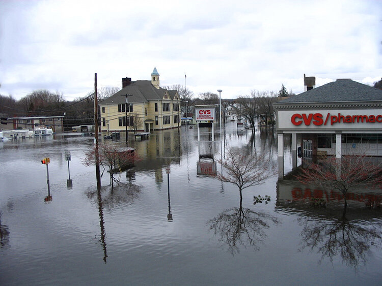
Rhode Island could see a repeat of the March 2010 floods that wreaked havoc statewide.
Warwick knows there will be flooding
Crean, of URI’s Coastal Resources Center who works with communities facing potential climate impacts, is particularly concerned, in the face of a Hurricane Rhody scenario, about Warwick, what with its history of flooding.
“Just to the east of the airport, but just north of Warwick Neck, is a whole system of wetlands and streams and tributaries into [Narragansett] bay,” Crean said. “If storm surge and rain hit, that creates a swath of flooding that cuts Warwick Neck off. There’s an emergency facility just north of Warwick Neck that would be physically cut off, so it’s important for the Warwick EMA [Emergency Management Agency] to know, first of all, to evacuate Warwick Neck. And if we want to be able to put out fires or whatever, they have to stage equipment in accessible locations because the area could be impassable.”
Part of Warwick’s problem also lies with its considerable collection of impervious surfaces, according to Peter August, a URI professor and former director of the university’s Coastal Institute.
“It’s all the roads and parking lots, and when the rain falls, it can’t soak into the ground. It has to run off someplace,” he said. “Plus, they put the mall in the exact spot you would never want to put a mall; it’s an oxbow, a bow-shaped bend in a river that floods easily, and so that’s gonna be tough.”
The Warwick Mall was flooded by several feet of water during the late-March floods of nine years ago. A mall security guard had to be rescued by boat. Most stores had to be gutted and all inventory was declared a loss. The mall was allowed to reopen without having to do anything to address any future climate impacts.
To prepare for future flooding, the city of Warwick is revamping its hazard mitigation plan, as is required every five years. The purpose of the plan is to “reduce overall risk to the population and structures from future hazard events, while also reducing reliance on Federal funding in future disasters.”
The plan, which needs to be approved by the Federal Emergency Management Agency, paints a picture of what would happen if a hurricane, like Carol, hit today. Some of the numbers are overwhelming: 28,486 tons of debris, nearly $12 million in damage to commercial and industrial property, and $120,548,000 in residential property damage.
“Oakland beach would be almost completely washed out, and Warwick Neck would become inaccessible until the waters recede,” Vallee said.
Five percent of Warwick’s population is older than 65, and the city’s hazard mitigation plan notes that “residents in group homes, nursing homes, assisted living, or subsidized housing may not have the resources to shelter in place or evacuate.”
Warwick’s EMA director and chief of police, Col. Rick Rathbun, believes any hurricane would have an adverse impact on the entire city, both coastal and inland.
“Because of the size of the city and our proximity to the bay, I think a hurricane will impact the entire city, whether you’re living along the coast in Oakland Beach and Warwick Neck, or if you’re in the western part of the city near the West Warwick line,” he said. “I think the biggest challenge is having people take the threat seriously early on. But I think it’s human nature to wait and hope, and we see things like Hurricane Dorian and how it stayed offshore of our coast, and that brings a false sense of security. These storms are unpredictable and they can move rapidly.”
One sentence in the hazard mitigation plan sums up Rathbun’s concern: “A powerful storm can significantly cripple Warwick.”
Climate impacts have already arrived
So Hurricane Rhody arrives. It punishes Westerly. Slams Narragansett Bay. Overwhelms Warwick’s bay-connected rivers and tributaries with 3-4 feet of storm surge. Houses are swept off their foundations, debris smashes into buildings, trees fall, and power lines snap.
Then, Hurricane Rhody loops back around and dumps some 15 inches of rain for good measure. Coupled with rising seas, warming waters spawning more hurricanes, coastal erosion, and overdevelopment, the question is: Are we ready for this?
National Weather Service’s Vallee believes that state and local government are doing a lot to prepare, but he worries about the greater public.
“Rhode Island was the first state to have all of its municipalities be recognized as StormReady by the National Weather Service, which requires each town to undertake certain measures to be prepared,” he said.
This effort entails a few actions on the part of the community, ranging from establishing a 24-hour warning point and emergency operations center, to hosting community seminars, to creating a system to monitor weather conditions locally. And while towns are preparing for the worst, Vallee worries that people won’t take their local government’s preparations seriously.
“But the people … the only ones left who remember a massive hurricane and what it can do, well, there’s not many left,” he said.
Crean shares Vallee’s concerns.
“What is the tipping point for making that meaningful change?” Crean asked. “I would still say it’s an education process and conversation that we’re all having to try to figure out where the will is to make change.”
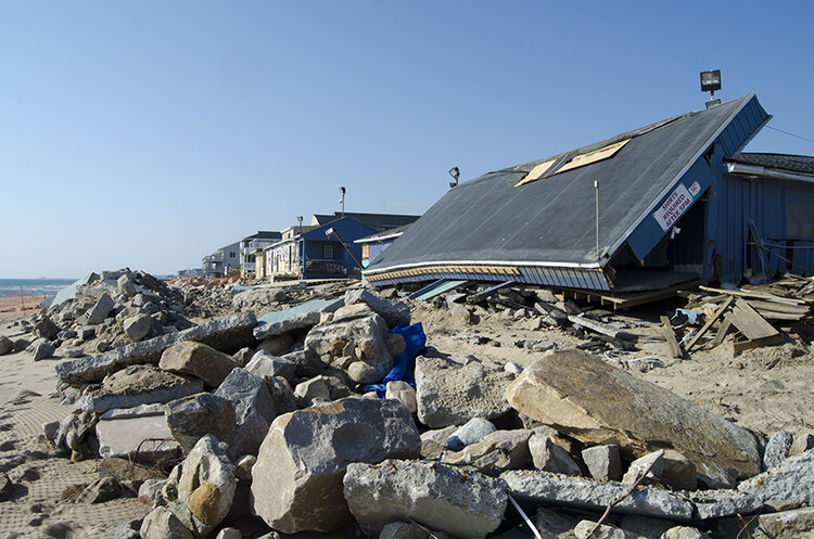
Some change comes in the form of adaptation. For example, the Misquamicut area along Atlantic Avenue in Westerly, one of the neighborhoods that was devastated by both the ’38 hurricane and more recently by Superstorm Sandy in 2012, some businesses have changed their entire model to account for future storms.
“Sam’s Snack Bar and the Little Mermaids lost everything during Sandy,” said Lisa Konicki, president of the Westerly-based Ocean Community Chamber of Commerce. “There was literally nothing left of Sam’s building, you couldn’t even tell that a building had been there. And Little Mermaids, there were a few pieces of the foundation wood that was sticking out of the sand, but the building, the roof, the walls, all that was gone. So those two businesses, rather than rebuild, opted to get concession trailers. So now their space is all mobile, and if there was a weather prediction similar to Sandy, they would simply unplug and drive away. They don’t want to go through it again.”
But while adapting your business and home might be the best option now, Crean said there may come a time when managed retreat is the only option.
“The sort of holy grail of all this is the idea of managed retreat,” she said. “At what point do you have to tell somebody you can’t live here anymore? That you can’t operate your business anymore? Wickford [a village in North Kingstown] may have to move or become a more water dependent village, because there won’t be a parking lot for visitors to use.”
The climate-related changes that are possible in Rhode Island are not just a futuristic doomsday warning; some of them have already happened or are happening.
“There’s a great image of downtown Wickford and once upon a time there was a store called Ryan’s Market. Now it’s The Kayak Centre,” Crean said.
Natural defenses matter
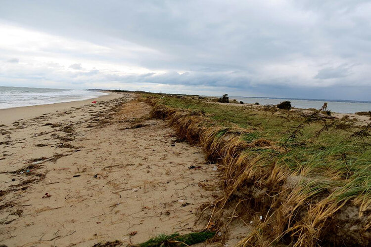
Sassi and August walk up one of the larger dunes at Napatree Point in Watch Hill. The sun beats down on visitors eager to soak up the last rays of summer, and piping plovers scatter across the sand.
“What’s amazing is that the during Superstorm Sandy ocean water crossed the dune in eight spots,” said August, a member of The Watch Hill Conservancy board of directors, pointing to the paths that twine down the swirling dunes. “On the bay side of the dune, in those breach sites, you had a classic washover fan, a big V shape path of pure white sand, not a leaf popping through it.”
He then gestured to the clusters of beach plum and waving fronds of beach grass.
“But the most striking thing to me was that three months later, you would have no way of knowing where that washover fan was, because the plants just shot up new stems from their roots and rhizomes, and it was business as usual,” August continued. “And the dunes just rolled over on themselves. It was pretty spectacular. There’s a theme of resilience here.”


as a civil engineer i certainly appreciate the increasing intensity of storms and flood damage and the biomass changes in local fisheries species (lobsters leaving and black sea bass arriving), all of which in my opinion are climate related. i lived on the water in new haven during hurricane carroll and have seen the intensifying winter storms destroy the back yard and seawall of that childhood home.
this article discusses a number of pertinent issues with respect to local impacts from what will be increasingly stronger and more frequent storms. i am however disappointed in the opening paragraphs of incindiary doomsday senerios which describes the worst case example so as to get the reader’s attention. a less emotional introduction would have been to discuss the ranges of potential climate related storm intensification as opposed to "chicken little the sky is falling". your approach to the topic does disservice to the issue and may cause readers to dismiss the article or not read it to the end.
The huge storms that would be associated with climate change happened many years ago. Recent decades have been calm and unfortunately that doesn’t fit the alarmist narrative. Sandy had to be renamed as a “superstorm” because in fact, it didn’t even qualify as a cat 1 hurricane. Just a powerful tropical storm that happened to arrive at the worst time in the tide cycle.
Give it a rest.
Fantastic post Grace! I had no idea the current research was beginning to show that the speed to which large storms passing through the area was slowing down, potentially magnifying the damage that they cause. One of my favorite nonfiction books on hurricanes is Storm World by Chris Mooney and I remember his take home message was that hurricanes are getting larger and more numerous. Now they’re moving more slowly? I was a coastal geology major at URI and always enjoyed compared making comparisons between hurricanes and dinosaurs. Our hurricanes are starting to resemble big t’rexes more than the quicker raptors I used to remember them as.
Also, as a geologist who minored in rhetoric, I was always being told that my writing was more literary and less scientific. I say embrace it. I’d cite some old dead Russian rhetoricians about why this is impactfulbut I won’t bore you….yet.