Report Indicates Bay Watershed Feeling Some Pressure
May 8, 2017
Share
The first round of public meetings for the draft report on the status of Narragansett Bay generated important feedback. To encourage additional public comment, the Narragansett Bay Estuary Program has scheduled two additional public meetings.
The Rhode Island meeting is scheduled for May 15 at 4 p.m. in Room 280C at the Rhode Island Department of Environmental Management headquarters, 235 Promenade St. in Providence. The Massachusetts meeting is scheduled for May 18 at 4 p.m. at the Southeastern Regional Planning and Economic Development District, 88 Broadway in Taunton.
The Narragansett Bay Estuary Program’s draft report “State of the Bay and its Watershed” assesses 24 indicators throughout the bay and its watershed — some 60 percent of the watershed is in Massachusetts — based on best available science and current research efforts.
Public comments on the draft report will be accepted until the close of business May 22. Comments should be e-mailed to [email protected]. The Narragansett Bay Estuary Program (NBEP) will revise and finalize the report and prepare a summary based on public feedback.
ecoRI News recently went through the report. Numerous indicators provide a glimpse into the health of the Narragansett Bay ecosystem. Here is a look at some detailed in the NBEP’s draft report:
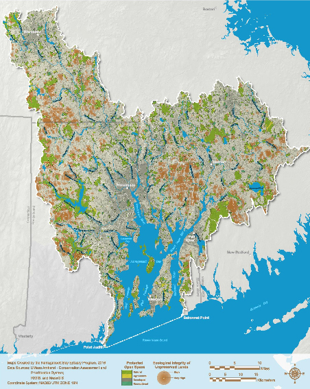
Open space in natural, unconverted condition provides benefits to the Narragansett Bay watershed’s terrestrial and aquatic ecosystems. Intact forests and riparian lands are critical for protecting the quality and quantity of surface water and groundwater, and are important for maintenance of ecosystem integrity.
Key finding: As of 2015, 171,244 acres of natural open-space land had been protected, representing more than 15 percent of the Narragansett Bay watershed. However, 17 percent of the watershed’s significant natural lands remain unprotected and could be developed.
Seagrasses are aquatic vascular flowering plants that help stabilize sediments and provide vital habitat and nursery grounds for fish and shellfish. Prior to the 1940s, the total extent of seagrass acreage in the estuarine waters of Narragansett Bay was vast — encompassing almost all sections of the bay, including the Providence River estuary and Mount Hope Bay. Seagrasses then declined markedly, and now they are found only in the lower bay.
The decline was caused by stressors such as nutrient enrichment — which encourages algae and epiphyte growth, thus shading the grass — physical disturbance, such as dredging, removal and storms, and a disease outbreak in the 1930s that caused extensive losses along the Atlantic Coast. Today, nutrient enrichment continues to be an important stressor, and climate change is increasingly affecting seagrasses through warming waters and rising sea level.
Key finding: From 2006 to 2012, Narragansett Bay showed substantial gains in seagrass acreage, although the gains aren’t enough to replace the acreage lost since the 1940s.
Salt marshes are critical resources that provide numerous benefits to Narragansett Bay, including nursery grounds and other habitat for fish and wildlife, protection from storms and flooding, and filtration of pollutants.
Most of the bay’s salt marshes were lost between the 1800s and the 1970s, mostly because of development, nutrient pollution and sea-level rise. It has been projected that 13 percent to 87 percent of existing salt marsh will be converted to open waters under both 1- and 5-foot sea level-rise scenarios.
Key finding: The National Wetlands Inventory survey has estimated a total of 4,854 acres of salt marsh across Narragansett Bay, Little Narragansett Bay and the Southwest Coastal Ponds.
Estuarine fish are important parts of Narragansett Bay’s food web, provide sustenance to humans, and serve as critical links between an estuary and the open ocean. While fishing, pollution and habitat loss all cause changes in estuarine fish communities, warming of coastal waters, which has been documented during the past 60 years and is projected to continue into the future, is an increasingly important stressor.
Key finding: Study results suggest that opportunistic seasonal migrant species have displaced the demersal resident species in the bay, partly due to increasing temperatures. All of these changes have altered the character of the Narragansett Bay fish community from a typical southern New England temperate estuarine community to one that is tending toward a Mid-Atlantic estuarine community.
Editor’s note: This is the second of three stories analyzing the draft report.
Categories
Join the Discussion
View Comments

Your support keeps our reporters on the environmental beat.
Reader support is at the core of our nonprofit news model. Together, we can keep the environment in the headlines.