Superstorm Sandy Showed Ocean State What Future Storms Could Look Like
November 3, 2022
Share
WESTERLY, R.I. — Superstorm Sandy was a complex, hybrid storm, the result of warm tropical air colliding with cold northern air. The storm reached Rhode Island on Oct. 29, 2012, causing significant damage to coastal homes and businesses. The National Flood Insurance Program paid more than $31 million in claims from Rhode Island alone.
Now, a decade later, researchers are developing ways to predict how severe storms will impact coastal communities.
Isaac Ginis, a professor at the University of Rhode Island’s Graduate School of Oceanography, develops storm-intensity prediction models, including a computer model used by the National Weather Service. Ginis described Sandy as the type of intense storm that might strike Rhode Island more often in the fall and winter.
“This happens in the winter time, when the temperature over land is getting colder and colder,” he said. “We typically have cooler air sliding down from Canada and then, the temperature of the water is still warm.”
That temperature difference, or gradient, produces nor’easters. As Sandy approached New England, getting energy from the warmer ocean water, Ginis explained the storm also began to draw energy from the atmosphere, with its warm/cold air temperature difference.
“This is what we’re calling an ‘extra-tropical transition,’ essentially, and that actually makes our storms more complex in New England,” he said.
Although there were no Sandy-related deaths in Rhode Island, the storm was massive, covering about 900 miles, and caused 117 deaths in the United States, most of them from drowning.
In Rhode Island, Sandy’s damage was most severe in Charlestown, Westerly, and Newport. Rhode Island Emergency Management Agency spokesperson Melissa Carden said the biggest challenges for the agency were making sure residents were safe and restoring services.
“The Westerly, Newport and Charlestown areas of the state were hardest hit by Sandy,” Carden wrote in an emailed comment. “Erosion, damaged buildings, blocked roadways and communications issues due to downed cell towers were some of the biggest issues. In terms of deployment of state resources, the biggest challenge was staffing to ensure the safety of all citizens through home checks and restoring the area to normalcy.”
Westerly building official Dave Murphy remembers his first look at the aftermath of the storm.
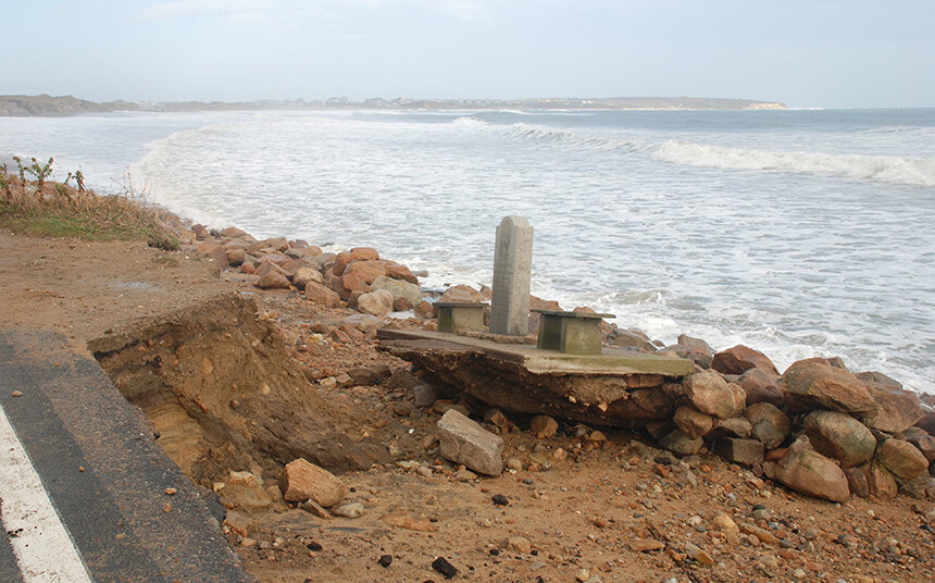
“I just remember driving down … turning off Shore Road onto one of the side streets and just noticing, you’re looking directly at the ocean,” he said. “There was no dune, in some cases, no building. It was very eerie, because you saw that first impression, you kind of take a step back and you’re like, ‘Oh my gosh. What’s going to be next?’”
Also assessing the damage was coastal geologist Janet Freedman, who at that time worked at the Coastal Resources Management Council (CRMC) and is now at URI’s Coastal Institute.
“We started in Charlestown by the South Kingstown border,” she said. “In Charlestown they had the cadaver dogs there, so we went in the other direction. There were some people who were missing, I believe. They were found.”
While it appeared immediately after Sandy that the south coast beaches had been washed away, Freedman said the sand returned quickly, without human intervention. Sand had also come ashore in large deposits called “overwash fans.”
“The sand that is eroded during a storm, some of it goes offshore too deep to come back, but a lot of it will go offshore in sand bars and a lot of it goes in the overwash if your storm surge is high enough, a lot of it’s just moved landward into the street, like we saw in Westerly,” she said. “So, the sand bars that are offshore, the waves will push that sand back onto the beach, and this process doesn’t take that long, so that reservoir of sand did come back to the beaches, within a week or so.”
That natural recovery was enhanced in 2014 at Misquamicut Beach, in an Army Corps of Engineers sand replenishment project.
Pamela Rubinoff, associate coastal manager at the Coastal Resources Center, helps communities develop strategies to adapt to impacts of a changing climate, including rising sea levels and storm surge. Severe storms, she said, are becoming more frequent.
“I would like to put Sandy in context,” she said. “Remember that we had the 2010 devastating floods inland, and then we had, in 2011, Irene, with incredible amounts of rain. And then we had Superstorm Sandy, which was a coastal storm, and then we had, in 2013, winter storm Nemo. So, you know, we really had a wake-up call on all fronts there, and obviously since, but it was one after another. … I think there was a big awareness of everybody that things are not the same here and that we have a changing world.”
In Newport, Rep. Lauren Carson believes Hurricane Ian, a category 4 storm that hit the Fort Myers area in Florida on Sept. 28 and killed more than 100 people, has served as a warning to Rhode Islanders.
“I think that Ian in Florida was a huge wake-up call for communities all across the country,” she said. “I think they saw a hurricane unlike anything that we’ve seen in our lifetimes and I think that will boost communities to be more proactive. I know that there are neighborhoods in Newport that are more vulnerable. I think that the community knows that.”
But even as they begin to recover from Hurricane Ian, residents and business owners are vowing to rebuild, just as they did in Rhode Island after Superstorm Sandy.
Freedman described the recovery period immediately following Sandy as “chaotic.”
“One of the things that I thought wasn’t really good, in the chaos, a lot of the shoreline structures, I think, rebuilt a lot bigger than they had been prior to that,” she said. “Now, part of it is, you have a grandfathered structure, you wanted to build it so that it would be effective, but I sense that many of them were much bigger and better than what had been there previously. Like, somebody may have had a row of boulders and suddenly, it’s a giant revetment. I think it was statewide along the shoreline.”
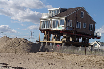
Murphy said Westerly residents are apprised of the risks and requirements of living in a flood zone, and some choose to raise their homes above flood level.
“We still allow construction in the flood zone,” he said. “We do notify the homeowner of the apparent risks that are there. We have implemented higher regulatory standards with freeboard requirements. Freeboard is that level of safety above the flood zone. The state requires one foot. The town allows up to five feet of freeboard. … You can elevate a home with three feet of freeboard and your flood insurance will be next to nothing, less than $1,000 a year.”
Rubinoff noted Sandy added an element of urgency to the completion of the Special Area Management Plan, or SAMP, for coastal Rhode Island.
“Superstorm Sandy really gave that a momentum to start working on that in earnest, to really look at the whole shoreline,” she said. “I think, from a perspective of the coastal area, that really gave us a good context of what are the current conditions and what are the changing conditions.”
As part of the SAMP, the STORMTOOLS portal was created to allow members of the public as well as policymakers to assess storm flooding potential.
The Coastal Hazards Application is another new planning resource.
“Everybody who’s proposing something on the shore and is getting a permit from CRMC, they have to go through a process that analyses what the change in sea-level rise will be for the life of the project and then, what the storm surge looks like at that time,” Rubinoff said.
As part of the state’s Resilient Rhody climate action strategy launched in 2018, the Rhode Island Infrastructure Bank, through the Municipal Resilience Program, helps communities develop climate adaptation strategies and, once they have completed the program, enables them to apply for project grants.
Ginis and his team recently launched their latest modeling tool, the Rhode Island Coastal Hazards, Analysis, Modeling and Prediction, or RI-CHAMP. The model shows, in real time, the impacts of severe weather on local infrastructure.
“That’s the main reason we built this RI-CHAMP system, that is not just a storm forecast system, but rather the impact prediction system,” Ginis said. “Of course, more coastal communities are realizing that the climate is changing and probably that things will get worse, but instead of panicking, we need to come up with solutions, right? And in order to come up with solutions, we need to be informed about what to anticipate or what to expect and that, I think, is a big gap at the present time — a gap of knowledge from a local perspective.”
The need for adaptation strategies will become more urgent, with storms more devastating than Sandy certain to hit Rhode Island.
“The ’38 hurricane is something that we have to anticipate is going to happen again, and it may be worse with sea level rise,” Freedman said. “We’re 10 inches or 12 inches higher than when that hit. The storm surge is going to be that much higher.”