Setting Fire Record Straight: Pair of ’51 Fires Roared Through South County, Burrillville
January 1, 2024
Share
BURRILLVILLE, R.I. — When a brush fire swept through Exeter last April, burning roughly 600 acres at the Queen River Nature Preserve, it was described as the largest brush fire the state has seen since 1942.
Except it wasn’t.
That honor goes to two fires that simultaneously burned a total of more than 10,000 acres in northern Rhode Island and Washington County on May 2, 1951.
A story in The Woonsocket Call and Evening Reporter dated May 3, 1951, describes the Burrillville fire’s “roaring flames raging out of control over a three-mile area” on Buck Hill Road that officials worried would reach the Wallum Lake Sanitorium, now part of Zambarano Hospital. The fire eventually burned more than 2,000 acres of timberland in northern Rhode Island.
According to the article, the fire started Wednesday, May 2, 1951, in Douglas, Mass., and spread to Webster, Mass., before moving south into Burrillville. “Firemen noted that a shift of the wind to the southward would imperil homes in the Jackson Schoolhouse and Eagle Peak sections of Burrillville,” according to The Call.
The Washington County fire took the life of firefighter John Ray Clark, 52, according to a story in The Westerly Sun on May 13, 1951. That story described a fire that took more than 24 hours to contain and burned more than 7,000 acres.
So how did fires of this magnitude get overlooked when comparisons to the recent Exeter fire were sought? According to Evan LaCross, a spokesperson for the Rhode Island Department of Environmental Management, it was due to lackluster record-keeping.
“Rhode Island’s state fire records were non-uniformly maintained in the 1940s,” LaCross said, “and it wasn’t until 1962 that records were formalized on size and acreage burned. Although the accuracy of fire record-keeping from this time is scattered, it’s accurate to say that Rhode Island has not experienced fires with this type of rapid growth and spread since the mid-20th century.”
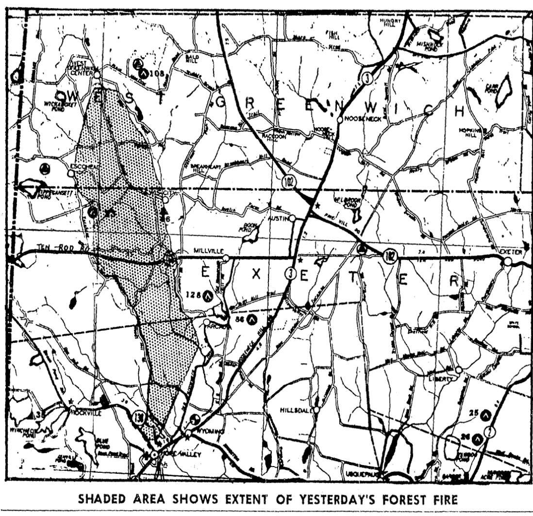
According to the Westerly Sun story, the fire that burned acreage from West Greenwich to Hope Valley was set on purpose. Clark was part of a four-man firefighting crew on a water pumper that was briefly trapped on property on Escoheag Hill. The paper reported, “The truck and men, with their avenue of escape cut off, and a broken water pump, made a heroic effort to come safely through the roaring inferno. Clark, riding on the back step of the big pumper, inhaled large quantities of smoke and flame.”
Clark insisted on staying with the broken pumper until it arrived back at the Hope Valley Fire Station, at which point his fellow firefighters convinced Clark to go home and get treated. His condition was so bad, a local doctor said, according to the story, that he was unable to be moved to a hospital for treatment and died at home.
The fire burned from West Greenwich center to Hope Valley, destroying buildings and homes along the way. At least one other firefighter was severely burned as a result of fighting the blaze.
William Eccleston, a Burrillville native who alerted ecoRI News to the 1951 fires, remembers driving to the Thompson, Conn., golf course near the border with Burrillville with his parents in the 1950s and ’60s and “all of a sudden there was this vista spreading to the horizon of vivid green eight- to ten-foot high brush — hundreds of charred dead snags poking up 15 to 20 feet above it. Up through the ’90s I could still find some of the charred stumps.”
“It does appear that the 1951 wildfires were larger than the 1942 fires that have been used as a comparison with [last] year’s wildfires,” LaCross said.

The smoke from the Escoheag fire was very impressive from our haylot 20 miles to the west in Norwichtown. It was a very clear day on a wind from the northwest. The bigger kids were jumping in their cars to go over to Beach Pond to fight the fire.