Providence Plans to Connect Neighborhood Greenways to Urban Trail Network That Creates Great Streets
August 26, 2020
Share
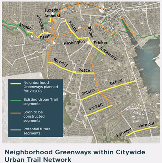
Part of the Urban Trail Network and Great Streets initiative, Providence’s latest pedestrian, bicycle, and alternative transportation-friendly changes will occur on 10 streets scattered through the South Side, Olneyville, Washington Park, and Federal Hill neighborhoods.
The 10 “neighborhood greenway” streets are: Aleppo Street, from Manton Avenue to Riverside Park; Delaine Street, Manton Avenue to Harris Avenue; Tuxedo Avenue and Amherst Street, Atwells Avenue to Valley Street; Sonoma Court, Delaine Street to Donigian Park; Oxford and Ontario streets, Allens Avenue to Elmwood Avenue; Sackett Street, Elmwood Avenue to Broad Street; Farragut and Vermont avenues, Roger Williams Park to Michigan Avenue; Peace and Waverly streets, Prairie Avenue to 6/10 Service Road; Fricker and Lockwood streets, Atwells Avenue to Westminster Street; and Knight, Washington, and Winter streets, Westminster Street to Prairie Avenue.
The Great Streets initiative proposes an Urban Trail Network of off-road separated paths, separated on-road trails, and low-stress neighborhood greenways that are designed to make Providence more livable and revitalize and connect its neighborhoods with a safe transportation system that serves everyone.
The city’s Department of Planning and Development held a recent public information meeting to update residents on the creation of neighborhood greenways.
“So, why did we choose these streets?” Alex Ellis, principal planner for the city, said during the Aug. 25 online meeting. “We went through a full process for prioritizing segments of the Urban Trail Network for how soon they would happen, and the big factors we looked at were connectivity, access, and equity.”
Connectivity is an obvious factor in the new trail segment placement, as the new segments must connect to existing or future parts of the Urban Trail Network. Access includes taking note of what’s around the trail — for example, does the trail provide a way to various cultural institutions, libraries, or businesses?
Regarding equity, Ellis noted that transportation methods were often created without the best interests of Black and Brown communities in mind.
“It’s really important that we are investing in our neighborhoods equitably,” he said. “Transportation planning in Rhode Island has made unhealthy decisions in the past and too often in the present that disproportionally impact communities of color. And it’s important that as part of this government that recognizes that is wrong, we’re working to actively overcome that and make different decisions.”
The changes that will be made to these street segments, Ellis noted, aren’t the same drastic changes that have and will be made on larger, busier roads.
“Neighborhood greenways are not two-way protected trails,” he said. “They’re also not off-road shared use paths like Riverside Park and the East Bay Bike Path.”
Instead, making a neighborhood greenway entails inserting modest changes that ensure traffic calming in residential areas.
“The basic idea is to take a street that is already pretty low traffic … and really add features to make sure that people aren’t speeding down the street … so that you can feel safe having your kids cross the street or biking with someone who is not as experienced without fear of someone trying to go 35 and honk at you,” Ellis said.
Some of these traffic-calming solutions include speed lumps, shared lane markings (sharrows), contra-flow bike lanes, and, in the future, wayfinding signs.
Speed lumps, which make up a good amount of the traffic-calming measures, are spaced out, low bumps that allow emergency vehicles to pass at high speeds but slow down cars.
Sharrows — painted green signs on the pavement — make vehicles better aware of cyclists, while contra-flow bike lanes allow cyclists to travel in the opposite direction of traffic (these will be installed on one-way streets). Wayfinding signs help people find their way to attractions and landmarks and other parts of the urban trail.
Feedback on the neighborhood greenways was mostly positive. Nic Canning wrote, “Very supportive! Yay!” in the comment box on Zoom, while a person named Christian wrote, “Love the contraflow bike lane on Lockwood and Knight, and improvements to Fricker—thank you!”
The modifications of the 10 streets that are part of this latest installment of neighborhood greenways will span 2020-2021.
Categories
Join the Discussion
View Comments
Your support keeps our reporters on the environmental beat.
Reader support is at the core of our nonprofit news model. Together, we can keep the environment in the headlines.