Newport’s Choice: Offshore Wind or Massive Flooding
December 4, 2023
Several anti-wind farm posts have appeared recently on social media platforms.
While banning offshore wind may preserve pristine views, there will be few people around to see it.
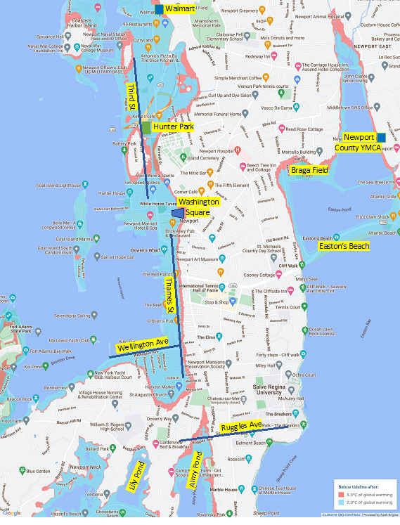
The alternative to new energy sources such as offshore wind and solar is a disastrously flooded Newport, as shown in the map below.

The blue area shows the current sea level, while the aqua area shows the sea level rise that could occur by 2050 if global temperatures rise by 2 degrees Celsius (3.6 degrees Fahrenheit). Pink areas show the sea level rise by 3 degrees C (5.4 degrees F).
To the north, the sea will be lapping against the doors of Walmart and Stop & Shop. Parking will be a nightmare.
Most of the Point will be underwater — the blue line highlights Third Street.
One of Newport’s hottest current issues, the noise from pickleball at Hunter Park, will no longer be a problem. Hunter Park will be underwater.
Continuing south, we see that Washington Square, America’s Cup Avenue, and Thames Street are all underwater. Newport weekends will be a lot quieter.
The area around Wellington Avenue is low-lying and the entire area will be flooded. If St. Augustin can be saved, parishioners will be able to boat to church.
Further south, both Lily and Almy ponds will flood their immediate surroundings. Almy Pond will expand north beyond Ruggles Avenue, destroying valuable real estate.
In the east, the ocean will overwhelm Easton’s Beach and expand into Easton’s Pond and Braga Field.
A challenge for Newport and Middletown will be to agree (a rarity) and to find millions of dollars to build a massive retaining wall around the reservoir to protect the island’s water supply.
Those are just some of the physical impacts of the sea level rise. Not discussed are the financial losses from the elimination of real estate and their property taxes, the total replacement of storm drains, and the cost of moving utilities.
The alternative to banning offshore wind is a disastrously flooded Newport. Most of the features that currently make Newport an attractive and livable city will be underwater.
Technical notes
The “do nothing” scenario, which is presented in the map, assumes that we continue to burn fossil fuels and do not transition to renewable energy sources. Technically, the “do nothing” scenario is called the Representative Concentration Pathway, RCP8.5.
Since the world recently exceeded the 1.5-degree Paris Treaty target, even if it was only temporary, we are already uncomfortably close to a 2 degree rise in global temperature.
If we continue to burn fossil fuels and do nothing to combat climate change, warming temperatures will cause seawater to expand in volume and ice over land to melt. Both effects cause a rise in sea level.
The world’s biggest climate modelling system project, led by Oxford University’s Dan Rowlands, predicts that if we continue to emit greenhouse gases at the current rate, the Earth may warm by 3 degrees Celsius by 2050. According to Rowlands, a 3-degree rise is equally as plausible as a rise of 1.4 degrees.
Roger Warburton, Ph.D., is a Newport, R.I., resident. He can be reached at [email protected]. The map is from Climate Central.
Categories
Join the Discussion
View CommentsRecent Comments
Leave a Reply
Your support keeps our reporters on the environmental beat.
Reader support is at the core of our nonprofit news model. Together, we can keep the environment in the headlines.
We use cookies to improve your experience and deliver personalized content. View Cookie Settings


Climate deniers and delayers should be tried for manslaughter as people are already dying from the climate catastrophe. Deaths in Phoenix AZ doubled this year to over 600 in just Phoenix.
This article left a bad taste in my mouth. I believe in climate change and doing whatever we can to save the planet but when people try to make things so black and white, so reductive, so this or that, it’s problematic. The climate issue is nuanced and complicated and the details matter. We all know about rising seas but attaching it to one offshore project is ridiculous as an example.