Irresponsible Motorists Tear Up Dunes, Bird Nests for Fun
May 23, 2024
Share
WESTERLY, R.I. — Doughnuts, retied yellow rope, and sawed-off signposts mark where dunes and piping plover nests should rest, in peace. But thoughtless motorists, empowered by commercials that glamorize Jeeps pulverizing non-pavement space, treat the Quonochontaug Sand Trail, and the dunes and beach that run parallel with it, as their private racetrack.
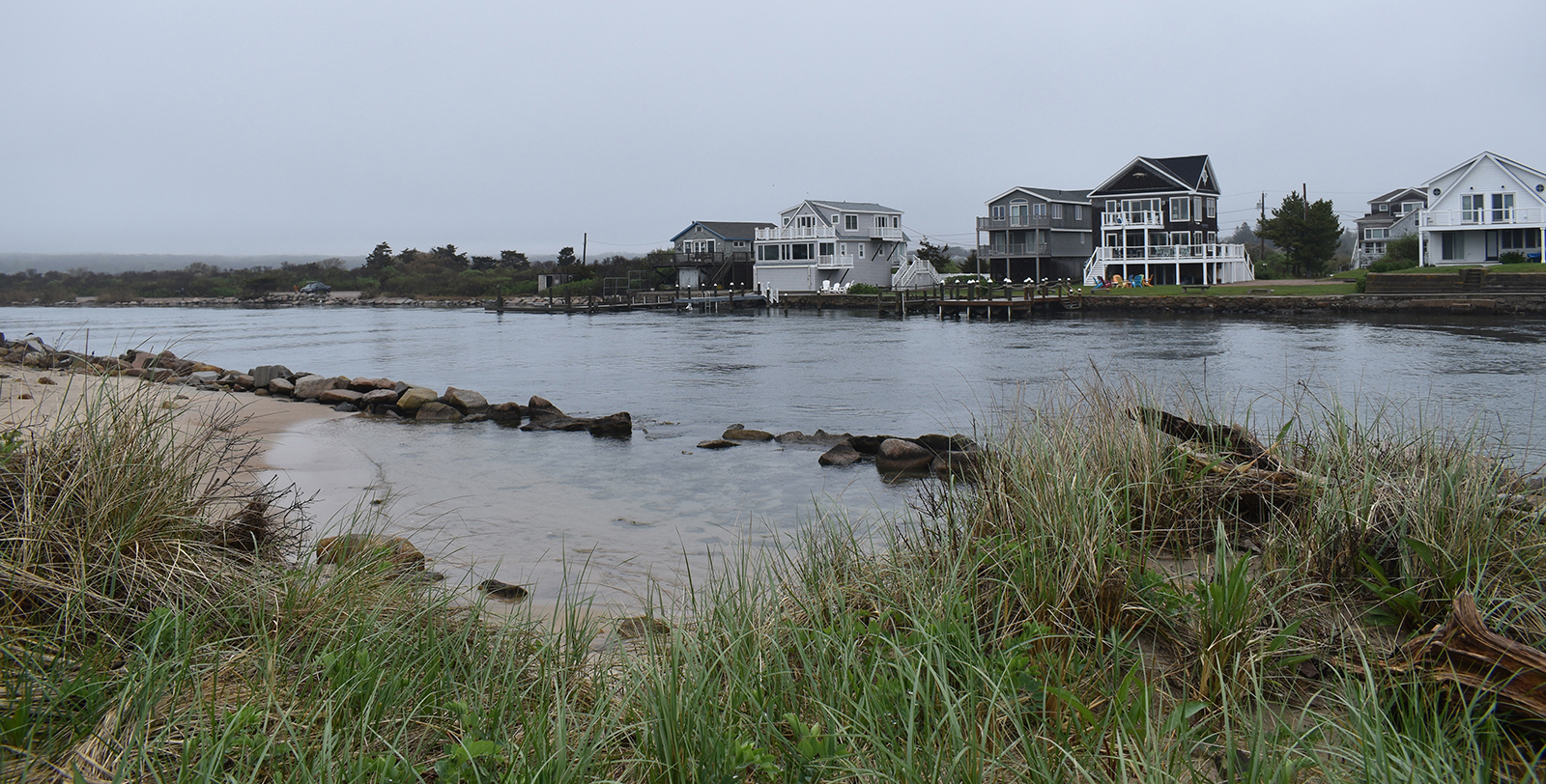
The Sand Trail, 15 feet wide at best in some spots, runs along much of Quonochontaug Beach, one of the few remaining undeveloped barrier beaches in Rhode Island. This fragile stretch of sand runs nearly 2 miles between Spray Rock Road to a breachway in Charlestown. It encompasses some 150 acres, which are largely privately owned — the Rhode Island Department of Environmental Management owns some of the land at the tip that touches the Quonochontaug Breachway. It separates Quonochontaug Pond from the Atlantic Ocean, and is one of the Ocean State’s most beautiful coastal spots.
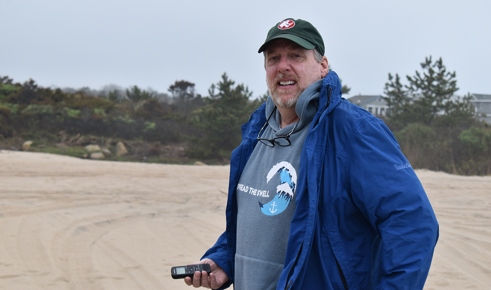
For those such as Westerly resident Michael Sands, “Quonnie Beach,” as the locals call it, is a tranquil coastal oasis whose ecological and social value easily exceeds its size.
This barrier beach is “a unique and special place for us all to enjoy,” according to the Nope’s Island Conservation Association (NICA). Sands is the nonprofit’s president. About 40% of the Quonochontaug coastal area is owned and protected by NICA. (Nope’s Island is a small island in Quonochontaug Pond that is home to a stand of trees.)
The nonprofit’s mission is to preserve Quonochontaug Beach as a “sustainable ecological environment capable of supporting plant and animal life and encouraging passive enjoyment of the beach by residents and visitors.”
This thankless job, including retying cut rope, being done by volunteers with a budget dependent upon donations and grants, is made more difficult by jackassery.
State law prohibits vehicles on dunes and within 75 feet of the dune crest, except on trails marked expressly for vehicular use. Alteration of the foredune zone adjacent to Type 1 (conservation) and Type 2 (low-intensity use) shoreline areas — Quonochontaug Beach is the former — is prohibited, except where the primary purpose is non-structural protection, restoration, nourishment, or improvement of the feature as a natural habitat.
Tire tracks and doughnuts don’t provide any of those services. In fact, they make that work both necessary and impossible.
“We can’t plant seagrass if people keep driving on the dunes,” Sands said. “It can’t happen when people are trampling it, and whipping doughnuts, and doing whatever they feel like down here.”
“Whatever they feel like” includes using the dunes as a toilet.
Vehicles are allowed to cruise the Sand Trail year-round, but driving on the beach is forbidden and parking is prohibited on the beach face and along the trail. Doughnuts, not the Allie’s kind, are most definitely illegal.
The Sand Trail parallels the shoreline from Spray Rock Road, formerly Spring Avenue, and crosses into Charlestown, ending on the western side of the Breachway. It provides the only land access to the peninsula, and crosses properties owned by the Weekapaug Fire District, the Weekapaug Foundation, the Haversham Beach Trust, the Shelter Harbor Fire District, the Rhode Island Mobile Sportsmen, the Anderson family, and the Nope’s Island Conservation Association.
Sands was named NICA’s president last August, and he’s been on the board for three years. He and the board of directors are committed to taking a more active role in Quonochontaug Beach’s conservation.
“This was an old conservation organization that was really pretty passive, and given the amount of use since COVID, we had to take a very active role,” he said. “We’ve worked really hard to pull that together.”
In March, Sands gave a PowerPoint presentation to local and state officials, including Westerly and Charlestown police, citing NICA’s concerns about allowing public vehicles on the Sand Trail. He noted this parade of traffic causes further erosion and accelerates the fragile beach’s destruction. He said motorists who don’t follow the rules and steal no-parking signs cause the most damage.
“We’re not believers that driving on the beach makes a lot of sense,” Sands told me during a recent tour he gave me of the South County barrier beach. “Public access doesn’t mean vehicle access. It just means it’s going to go away faster. We should be enjoying it responsibly.”
While he and NICA appreciate and support the public’s right to the shoreline as guaranteed in the state Constitution, Sands likes to note that the same paragraph also talks about protecting and conserving Rhode Island’s natural resources.
He wants the public to enjoy “our property.” In fact, NICA is implementing many of the conservation practices used at Napatree Point, which can get jammed in the summer. Vehicles, though, aren’t allowed on the Watch Hill peninsula. NICA’s new practices include creating a board of science advisors, planting native species, removing invasives, and more signage that points to beach access.
NICA believes traffic should be limited to the area’s land owners, for getting to their properties and for restoration work.
Sands noted the Sand Trail is used by businesses to drop off kayakers and other beachgoers. All of this traffic, both legal and illegal, is speeding up the barrier beach’s inevitable disappearance.
“This is a great recreation area, and everybody has the ability to come and enjoy this pristine piece of property,” Sands said. “If you’re bombing down here in Jeeps and ripping into dunes, it’s like finding logging in the middle of a national park. That’s why we’re trying to raise awareness so that people understand, yes, there’s this beautiful resource, use it, but don’t drive on it.”
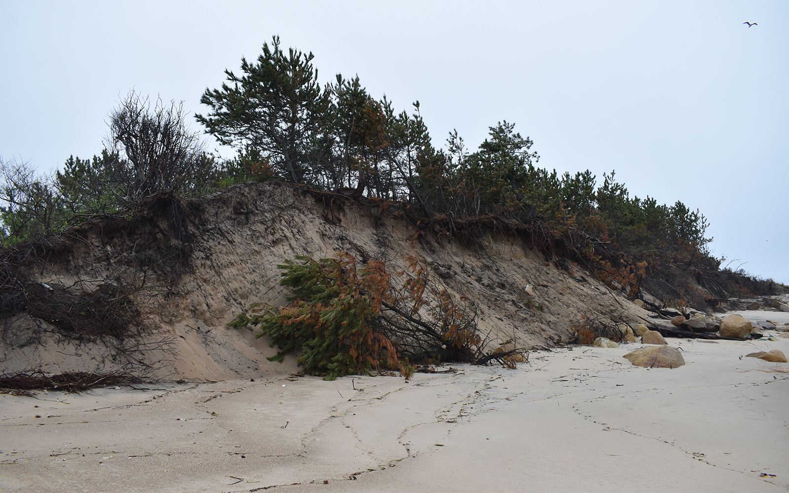
He said there are sections of the barrier beach, especially the jetty at the Charlestown end, that are in danger of disappearing, now.
“The water breaches the jetty and comes in on the backside, and there’s about two feet between the front and the back,” Sands said. “The next hurricane, it’s going to flow right through. You know, the next high storm, it’s going to take it right out.”
His March 13 presentation included a chart showing the state (DEM and CRMC) and municipal (Westerly and Charlestown) regulations pertaining to motor vehicle restrictions along this section of Rhode Island’s coast. Vehicle access is strictly limited, at least on paper, but enforcement is essentially nonexistent.
Sands acknowledged DEM and CRMC don’t have the resources necessary to effectively enforce 420 miles of shoreline, which is why he hopes the two municipalities will have the ability to step up their enforce of Quonnie’s rules this summer.
Sands noted the area is subject to the Coastal Resources Management Council’s Salt Pond Region Special Area Management Plan (SAMP) regulations, which apply additional restrictions to ensure increased protection for the natural resources and coastal features of the state’s salt pond region.
One of the goals of the SAMP is to “restore barrier beaches, salt marshes, and fish and wildlife habitats damaged by past construction or present use.” It notes that dunes on barrier beaches haven’t even recovered from pre-1984 storms, and that “trampling by people and vehicles remains a major problem.”
The CRMC regulations also note that “south shore beaches are sand-starved and have an exceptionally narrow and low profile, which leaves them susceptible to erosion and overwash.”
Most of state’s southern beaches are eroding. Shoreline change maps show that the shoreline in many places, including Quonnie Beach, receded more than 200 feet between 1939 and 2014, according to CRMC.
“Coastal barriers are constantly shifting landforms that shield the salt ponds, wetlands and the low lying mainland from the ravages of coastal storms by absorbing and dissipating the energy of storm driven waves,” according to the CRMC document titled Beaches and Sand Trails of Southern Rhode Island.
Sand’s presentation included photos showing recent damage and recent motor vehicle violations. A 2023 NICA-made video documents a host of illegal driving and dune parking destruction. Most of the vehicles are Jeeps, with some pickups.
NICA has also documented, with photos here and here, of the rope used to identify piping plover nesting areas cut and tire tracks marring the protected areas.
Fourteen years after the “Great New England Hurricane” ripped through an unsuspecting populace and its hardened shoreline, a group of Quonochontaug Pond residents bought much of a barrier beach to protect it from future development.
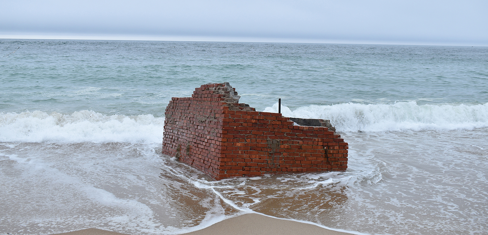
The hurricane of 1938 pummeled a 7-mile stretch of South County barrier beach, including Quonochontaug. Ninety-nine percent of the shoreline properties, some 700 buildings, were demolished.
NICA formed in the wake of that 1952 land purchase, by Nope’s Island Association Inc.
As a barrier beach, Quonnie protects local salt marshes, Quonochontaug Pond, and the coastal communities that lie behind it from the surge of Block Island Sound and rising sea levels. But erosion — by both Mother Nature and irresponsible humans — is weakening the beach’s defenses and putting its own future at risk.
This stretch of barrier beach also provides habitat for many species of plants and animals, some of which are endangered or threatened, such as the piping plover, American oystercatcher, and least tern.
A study conducted last year by the Rhode Island Natural History Survey found the following plants and animals on the beach: 79 plant species, including five rare species and, unfortunately, 10 invasive species; 61 bird species, including one federally threatened, one state endangered, and seven of state concern; 10 species of mammals; and several species of invertebrates, including dragonflies, moths, tiger beetles, and horseshoe crabs.
Dune plants are vital to the health and stability of beaches, especially barrier beaches. They gather sand, shelter wildlife, protect wetlands, and limit coastal flooding.
Besides vehicle traffic, illegally parked cars, and all-terrain vehicles, this stretch of South County coast is also being trampled by careless feet.
Sands said that while great care is taken with signs and fencing to make sure visitors don’t walk upon the dunes and trample beach grasses and vegetated areas, it is a significant and growing problem.
The cutting of the yellow rope, though, is done by selfish motorists who know they shouldn’t be using this space to park or do doughnuts but feel entitled because they own a Jeep and bought a permit.
Frank Carini can be reached at [email protected]. His opinions don’t reflect those of ecoRI News.


Ignorance is such bliss. Over entitled, over privileged, under educated dirtbags with big expensive SUVs who think they need to live their lives like a truck sales commercial. We really should blame Jeep, Toyota, Chevy, heck even Subaru as well as any auto corporation that personifies this behavioral culture in young Americans. They’re really the ones to blame, as they plant the seed of destruction that grows. Once again, the environment endures our punishment.
So what are you doing about it? Unless you identify and fine them along with confiscation of their vehicles they will think they got away with it. An example needs to be made or it will continue.
Thanks for highlighting the long-standing problem of illegal driving and parking on this beach. Scientific studies that have clearly shown the destructive impact that vehicles have on barrier beaches including facilitating erosion, creating habitat loss and causing pollution. All of these environmental risks are shown in the troubling photographic evidence that you’ve presented of reckless and illegal behavior. Given the environmental risks, I don’t think there is justification for allowing vehicles on a beach at any time of year. I would urge the relevant municipalities and state bodies to monitor and enforce their own regulations before this valuable resource is compromised beyond recognition, or disappears completely.
Again “limiting to local home owners” does not solve the problem. it again limits use to all and benefits a few perpetrating our societies division.
Rather I force the current rules and laws and don’t use the cop out of “ limited resources “
How about a gate that public servants can open but keeps all other vehicles out? Walk ins welcome.
Where is the discussion about the legal battles over the rights to drive with the Mobile Sportsfishermen? AND that the sand trail under review at CRMC as a public right of way with a long history of legal fights. There is more to this story than this environmental take. This is about control and exclusion by the fire districts and their sister conservation groups, like Nopes. Every tactic possible is used to try to privatize the shore there. Dont buy it.
Manipulatively trying to blame vehicles for erosion caused by coastal storms doesn’t help NICA’s credibility. The roping mentioned is installed and maintained daily by USFW monitors not NICA and their volunteers. The validity of article contents is in question with overelaborations that bear no substantiated proof to his claims.
Good idea!
Thank you for highlighting the issues facing Quonnie Beach, which has diminished in size at the far end, especially over the past few years. The sea grasses, which help protect the marshlands and Quonnie Pond, are gone. Sen. Gu and Rep. Spears are correct about coastal resilience- we have a problem. The damage done to the dunes by storms and humans is extensive. The rules for driving on the beach face and dunes have been in place for years. They just haven’t been enforced. This is a fragile area that needs protection.
Thanks Frank for this important article. You are helping RI wake up again from the ignorance, greed and destructive self serving behavior humans are having on our natural resources. I’ve spent several summers recently on Quonnie pond and the barrier beach. The beauty is there still, but fading fast. I observed vehicles driving on the beach and parking feet from the shore line. Yup, it’s happening. And It will continue until the land owners put a stop to it – which I personally doubt will happen. Maybe I’ll be surprised. Let’s see.
The operative words in this story are “limited to local homeowners.” The history of this area is so steeped in “this is ours not yours” that nothing these houseowners say can be believed. The very few rich out of state houseowners have been keeping Rhode Islanders off miles of beaches for way too long. Behind the words look for the hidden motive.
Relevant CRMC regulations and Town ordinances should be posted and enforced. A Westerly Town ordinance forbids people driving a motor vehicle on private property, Town land, or conservation land without the written permission from the owner. Driving off the sand trail means one is driving on private property. The first offense receives a $250 fine. It goes up for additional offenses. Such revenue can pay for enforcement, if law enforcement chooses to enforce the law on this beach.
You highlite one or two ignorant and abusive cowboys that have disregarded CRMC rules and regulations as to proper vehicle traffic on the sand trails. This is NOT the way 99% of the public use this beach. To suggest this normal everyday occurrence is inaccurate and not true.
Harvey, local Law Enforcement has little to no jurisdiction when it comes to CMRC permit holders, that jurisdiction belongs to RIDEM who enforces the rules as written by CMRC. With coastal property there is a constitutional easement, hence why you see fishermen from Labor Day to Memorial Day driving on the beach in the off season. The fact remains the sand trail has been historically used as a fishing spot at the very end in Charlestown on the public trust land, and before that people drove on the beach face at the end until I imagine the Nopes and Weekapaug clan lobbied the state to change the rules. CMRC permit holders drive on east beach in Westerly, east beach in Charlestown and Charlestown beach, all the while transversing on private property at times. I would also like to point out that the Watch hill fire district drive their 4×4 utility vehicle on the beach face of Napatree point day and night in the spring and summer, running over piping plover nest along the way.
I have have notified the Charlestown town Councilors and sent them a copy of the 1997 judgment, I do believe the language is Labor Day to Memorial Day, rest assured those dates will not change in Charlestown. They are now well informed.
Excellent reporting.
Eliminating driving along that beach is required. Let’s hope the lands owners and RI residents can make that happen very soon.
Thank you for the article and highlighting the destruction that is happening on this important environmentally sensitive barrier beach. With the lack of enforcement and clear disregard for existing regulations the obvious answer is to take the next step and eliminate vehicle access in its entirety. Would better protect the property and relieve our public servants of the responsibilities they don’t seem to have.
This article by columnist Frank Carini is 99% lies and propaganda I heard people say Frank and Mike did’nt drink the coolaid they MADE the coolaid.
I have been driving on Quonnie since the early 1980’s enjoying the fishing, clamming and that slice of heaven called Quonnie.
NO BUDDY wants to preserve that barrier beach more than the fishermen.
vehicles have been driving on that barrier beach for over 100 years with very little if any substantial damage. What we have to worry about is mother nature she can and has destroyed dunes and shoreline in one 6 hr. tide.
The other most destructive thing happening out there is huge boulders that were placed there around 1990 to try and keep vehicles off of the beach front year round. They are currently causing erosion and scouring as predicted in a letter from URI professor John Boothroyd dated November 27 1991 which to this day 33 years later are destroying the dune. In the 1991 letter they were told to remove the rocks if possible.
Quonnie is a beautiful place, We are blessed to have it so all can enjoy.
Many false narratives in this story. Please get all information confirmed from other reliable sources. The source you used has one mission and that is keep all public out period Its not for conservation but privatization. The ocean is the main destructor of our shorelines. Gonna get a lot worst with sea level rise!
exactly
This is not excellent reporting, it is a one sided view of one persons staged stunt. I have had a permit to drive Quonny for seven years now. Mostly all of the CRMC beach driving permit holders are respectful and park in designated areas. Many fisherman use this trail to access the breachway. Why were the RIMS property owners not interviewed for this article? The rich NIMBY’s are using this issue to basically privatize historically public beaches. The joke of a walk on public access is untrue due to no real public parking in the area.
Wow!
Quite a few different opinions on this article.
The continued one sided propaganda continues to rear its ugly head. NOAA has predicted the potential for the worst hurricane season in decades. We had two spring storms that decimated our shoreline. Quonnie beach has been accessed for recreation and fishing since the breach way was built. To see the continued push to privatize our shoreline is infuriating. I say we let the state or feds take Quonnie, Fenway, and Napatree by imminent domain and turn them into state or national parks. The elitist fire districts with their quasi conservation groups need to go away. Vehicles have no choice but to turn around on the beach face . To say those tracks were from people doing donuts is absurd. Anyone that drives out there knows that you have to go slow and turn slow or you get stuck . Those tracks are from a vehicle turning around . Not doing donuts.
I love this 1991 letter reference. Read the whole letter please. The professor also says in this letter to place snow fence to keep 4wd off the beach and also says to move the sand trail back by the pond side to protect the beach. Let me know if you want a copy. I love the people that take facts out of context to mislead and discredit others like this example. Who are the real liars here? Judge for yourself.
Update, the Charlestown town council voted 3 nay and 2 yay to adopt the change in the ordinance.
The dates and original language will remain. Line B in the proposed ordinance would have opened up a can of worms as NICA claims the sand trail does not extend to our public trust land. “B. It shall be unlawful for any person to operate or drive a motor vehicle or on sand dunes adjacent to beaches within the Town at any time, except on traditional accessways.” The town of Charlestown sent the sand trail to the CMRC for public right of way consideration last year. That files remained open even though Weekapaug and or NICA lawyers petitioned to have it closed. The facts remain clear, the war over beach access is not over, as long as there are fire districts who restrict access the war will rage on. There are no private beaches in Rhode Island, we the people have a inalienable right to the shore. This right is not only written, it was common long before we where even a nation.
The wealthy elite have no more or less rights to the shore than the poor and downtrodden.